About Salt Creek

Bayboro Creek (1902), courtesy Pinellas County Heritage Village
Salt Creek feeds Bayboro Harbor, just south of downtown St. Petersburg, running northeast through the lower Pinellas Peninsula and into Tampa Bay. This mostly channelized stream cuts diagonally across the city street grid, and being mostly culverted, is largely overlooked. Few residents can trace Salt Creek from beginning to end.
The neglect is no accident, but rather, a by-product of social design. For over a century, St. Petersburg has been shaped by a century of structural racism, with poorer and majority Black residents on the city’s south side, and the creek suffers from a similar indifference–polluted, forgotten, dismissed as a ditch, at points, stripped of its very identity or name. For a narrative StoryMap about the creek, click here
Interactive map of south St. Petersburg creeks. (Tony Abbott)
Imagine the creek’s path (in reverse) from Tampa Bay to its sources in the center of lower Pinellas County. From Bayboro Harbor it enters the marina district, then passes through the Old Southeast, Bartlett Park, and Harbordale neighborhoods. After crossing Martin Luther King, Jr. (or Ninth) Street, it runs past a dam and into Lake Maggiore. Lake Maggiore, while a crucial part of Salt Creek, has its own complicated hydrology–it is sourced by springs, by the historically tidal creek, and run-off. The “upper” reaches of Salt Creek, feeding the lake, trace as far west as 34th Street (and Interstate 275) and south to the St. Petersburg Country Club golf course.
Salt Creek refuses the standard stories of St. Petersburg but carries its own unique charisma. Old St. Petersburg, historian Raymond Arsenault observes, has been defined by a mythology of “perpetual warmth, health, comfort, and leisure”; Salt Creek does not fit that narrative of a “Florida Dream.” Industrialized and polluted, the stream can feel wild but remote. Because of its many uses, its roles vary: it is at once a bird rookery; a natural resource, awaiting economic exploitation; drainage ditch; homeless shelter and toilet; fodder for artistic expression; a hidden space for illegal transactions; a place to fish; and an object for reform. Friends of Salt Creek privileges no one of these uses, but invites exploration of all kinds–asking only that we foreground the ways in which cleaning our waterways can serve our community.
Bayboro Harbor to Bartlett Pond
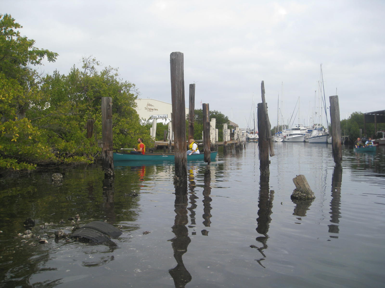
Courtesy, Christopher Campbell
Enter at Bayboro Harbor, a deep water port first dredged during a city boom at the turn of the twentieth century. The creek still carries the imprint of its early twentieth century history. A 1908 newspaper report described a “land-locked salt-water bay or marsh,” then called Fiddler’s Paradise. Boosters claimed that dredging could turn this “Eyesore” into a “Beauty Spot,” capable of supporting both commercial boat traffic and “pleasure yachts.” Five years later the estuarine channel was dredged to Fourth Street, cementing the identity of “Salt Lake Run” as a fragmented and urbanized stream.
The spatial follows racial lines. St. Petersburg’s history is defined by paradox: as a place of natural wonder and race-based inequity, both beautiful and violent. White tourists arrived in the first decades of the twentieth century, while African Americans came to work the railroads (laying the tracks that brought white tourists) and remaining to supply a leisure economy. In 1923 John Nolen, the leading urban planner of his day, offered a visionary strategy for future growth, St Petersburg Today, St Petersburg Tomorrow. Nolen’s ideas included a chain of parks, incorporating the Salt Creek basin, that would have linked Tampa Bay and Gulf Beaches in one green basin; voters rejected the design, however, fueled by a lobbying campaign that cast city planning as an infringement upon private property rights, plus claims that Nolen’s plan did not go far enough to isolate Black residents.
Salt Creek fits within a city plan that put recreation near the “front door” and service in back. North of Central Avenue, town leaders envisioned a chain of waterfront parks, scenic expressions of the City Beautiful Movement; a creek on the southern reaches, meanwhile, was slated for industrial use.
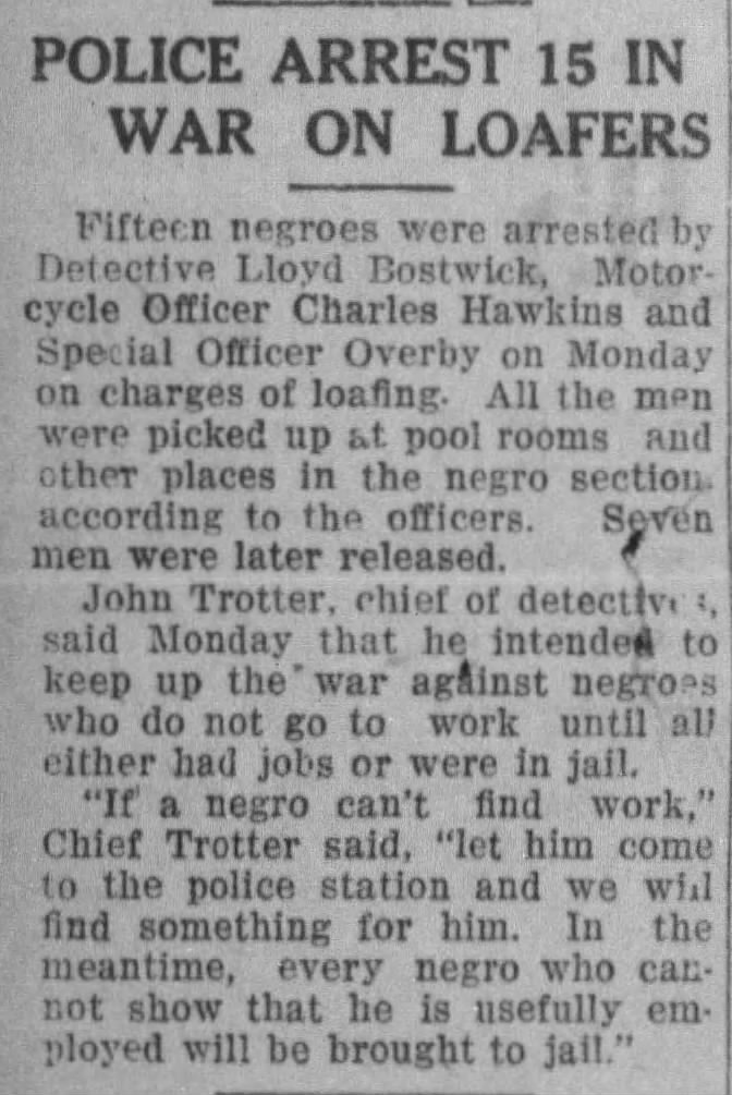 Sea walls throughout the city were built by African American men, arrested for spurious “vagrancy” laws, then put to public projects. Newspapers openly reported on the use of peonage labor. “If a negro can’t find work, let him come to the police station and we will find something for him,” a city detective boasted to reporters in 1924; “In the meantime, every negro who cannot show that he is usefully employed will be brought to jail.” Where conventional ideas of “Nature” celebrate untouched beauty, Salt Creek’s history cannot be separated from Black labor and civil rights.
Courtesy, Robin Shwedo
The creek remains a working waterway today, home to boatyard and marinas. Past the Third Street Bridge, a former trolley route known as Thrill Hill (built in 1926) the creek’s appearance changes dramatically. Waters remain tidal, as evidenced by the mullet fishing on Thrill Hill, though docks and marina salvage slowly give way to mangroves. The distinctive Sealtest Building (built 1937) and flash-freeze fish plant (the first of its kind on the Gulf) bracket wildlife, homeless encampments, boatyards, and a natural and built environment still in constant flux.
Salt Creek is defined by contradiction: industrialized yet wild, beautiful and polluted, a magnet for in-between groups and resource to be exploited or controlled by money and power. The first yachters along the creek complained to police about chicken thefts. Vague oversight through the mid-twentieth century resulted in oil spills. City Council labeled moorings a “maritime slum” in the 1960s, and over the following decade, abandoned boats continued to pile up. Newspapers and officials waged a long verbal war against Salt Creek squatters. Resident Vernon Agee, in a sensational but still exemplary case, fought back juvenile courts for months. (Agee, whose family lived aboard a ramshackle houseboat, predicted a coming ice age.) Drug traffic proliferated in the 1970s, with the docks serving as an unofficial port of call for Colombian cannabis. Pushed out of sight, the creek has long provided the space for marginalized individuals and communities to dwell and even organize. As the city has increased pressure on street people to leave more central city parks, many have encamped here, closer to social services, forming a well-structured homeless community.
In recent years, the undervalued lots adjacent to a thriving downtown have caught the attention of real estate development. Spurred by the promise of a multibillion dollar development, St. Petersburg’s City Council voted to change building codes to permit construction along the creek’s channel. The wisdom of encouraging construction in a flood plain–as storm events are predicted to intensify–remains to be seen.
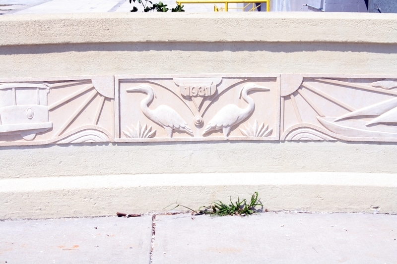
Harbordale to Lake Maggiore
Because of its history, Salt Creek has never lent itself to the conventional form of outdoor adventure. Only a “weirdo,” wrote long-time city reporter Jon Wilson in 1986, “would paddle this creek.” The banks grow wilder under the low-hanging Fourth Street bridge. The neighborhood here serves as rookery, shelter and bathroom for street people, as well as a sheltered space for hidden economies. Periodically the area is discussed as a canoe trail; the creek’s charm indeed lies in its wildness, set in the heart of a city. Yet water quality remains a concern, with fecal bacteria levels from build-up, wildlife, sewage leaks, and people as well as pets pooping along its banks.
Beauty comes unexpectedly. A tangled channel opens past the 18th Avenue South bridge, onto Bartlett Lake. Osprey roost in light poles from the nearby athletic fields and snook roil under the black muck. The creek feels both urbanized and remote. Dredge the pond, ignore the traffic, and one could imagine being in the Everglades.
Under a mangrove tunnel south of the pond, a water goat collects Styrofoam, plastic bottles, and debris. The channel gets quite shallow and tangled with prop roots past the 22nd Ave. South bridge. The walled creek, canopied by mangroves, cuts diagonally through the Harbordale neighborhood.
Poor water quality has plagued the creek and community for decades. Low oxygen levels led to fish kills in the 1960s; city council clamped down on children fishing and swimming during summer vacations. City officials in 1971 were calling the creek a “ditch,” while residents complained about the trash and stench, and in 1973, state officials tested coliform bacteria at eight times the level considered safe for human contact. Notably, water condition started making headlines just as segregation was coming to an end. As African Americans moved into formerly white-only neighborhoods, the city allowed the creek’s health to decline. In 1974 the city proposes a Conceptual Plan, a forward-thinking design that included a “natural green corridor” between Tampa Bay, Lake Maggiore, and Lake Maggiore; voteres reject the proposal.
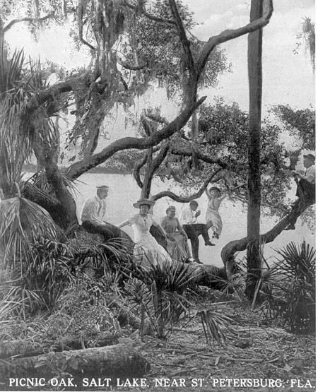
Lake Maggiore
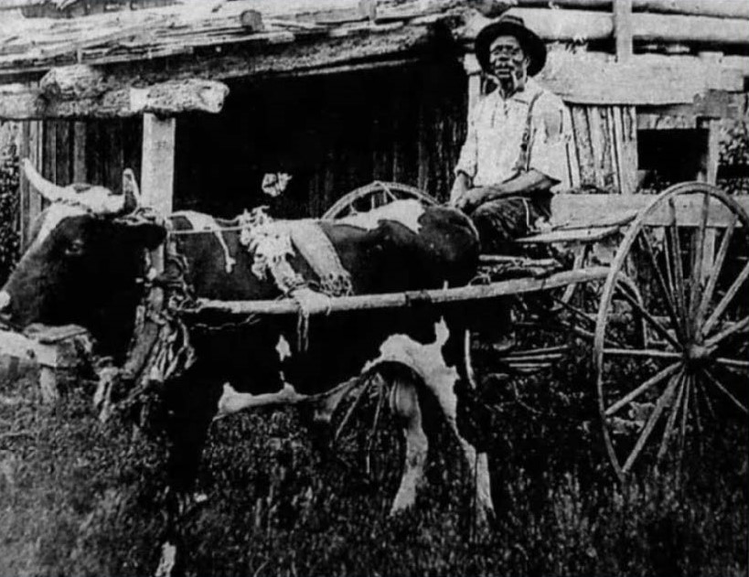
John Donaldson, courtesy Pinellas County Historical Society
Salt Creek transforms yet again on the West side of Martin Luther King, Jr. (MLK or 9th) Street. A dam (replaced several times) was built in the 1920s and is now maintained by the Southwest Florida Water Management District (or Swiftmud), controling water levels at Lake Maggiore.
First called Salt Lake, this 375-acre lake has a complex hydrology, combining run-off, underground springs, and tidal currents from the creek. The area’s African-American roots run deep. In 1868, John and Anna Donaldson settled here, and in 1871, purchased 40 acres near Tangerine Ave. (now 18th Avenue South); Donaldson is also famous for being St. Petersburg’s first Black postmaster.
 Along with its identity, Lake Maggiore name (first pronounced ma-JHORI, now Muh-GOR-y) has changed over the years. Real estate speculation peaked during a second property boom period, and in 1925 St. Petersburg Times article offered a requisite pirate tale, claiming inspiration from an a fanciful Italian map; developments such as “Pallanza Park” were promoted. Housing investment slumped during the Great Depression; after World War II, however, Florida’s population exploded–from 1,575 residents in 1900 to over 20,000 in 1923, plus seasonal population five times that number.
Courtesy, St. Petersburg Museum of History
Land use, in turn, has altered hydrology. Had the surrounding area been left in a natural state, Lake Maggiore would balance brackish water sources from the the bay, a half dozen springs, and surface runoff from the terrace sloping into the Maggiore Shores neighborhood. Instead, a concrete channel speeds the current into the lake, even as a dam seeks to divide freshwater and marine life. Fish kills are routine. Newspaper reports continue the refrain: in 1930, fish kills lead to talk of floodgates, reports the St. Petersburg Times; in 1940, low lake levels result in mullet die-offs and trout; in 1966, salt water intrusion suffocates catfish; in 1971 state biologists debate whether catfish death were a product of silt runoff or chlorides; and in 1991, the city declared the lake “sick from pollution” yet once more. In the first decade of 2000, Swiftmud completed a twenty-year, $17.8 million dollar restoration, dredging the silty bottom and restocking the waters with freshwater game fish. Precedent offers little hope that the most recent remediations will provide a long-term solution.
Lake Maggiore is surrounded by many stakeholders, each with a different claim to this body of water. In 1947 the city laid the first trail and what is now Boyd Hill Nature Preserve. A beloved oasis for nature in the heart of the city, the park’s human history is easily overlooked. (See Elizabeth M. Verbeck’s “informal” oral history of Boyd Hill, This Quiet Corner). Boyd Hill was previously home to exotics plants, plus a zoo featuring up to 500 parakeets, a pair of bear cubs, eight monkeys, and a pet alligator named Sam; the center reopened in 1980, without the zoo, and the attempt to “re-naturalize” the preserve continues. Vestiges of the old garden, including a stone bridge, remain today. Body Hill expanded in 1982, with the addition of a 47-acre tract to the West known as the Kirby Property. Former park manager Diana Kyle calls this beloved preserve: “a forest, surrounded by urbanization, saved by a touch of forethought.” At this point, Salt Creek disappears.
Upper Salt Creek
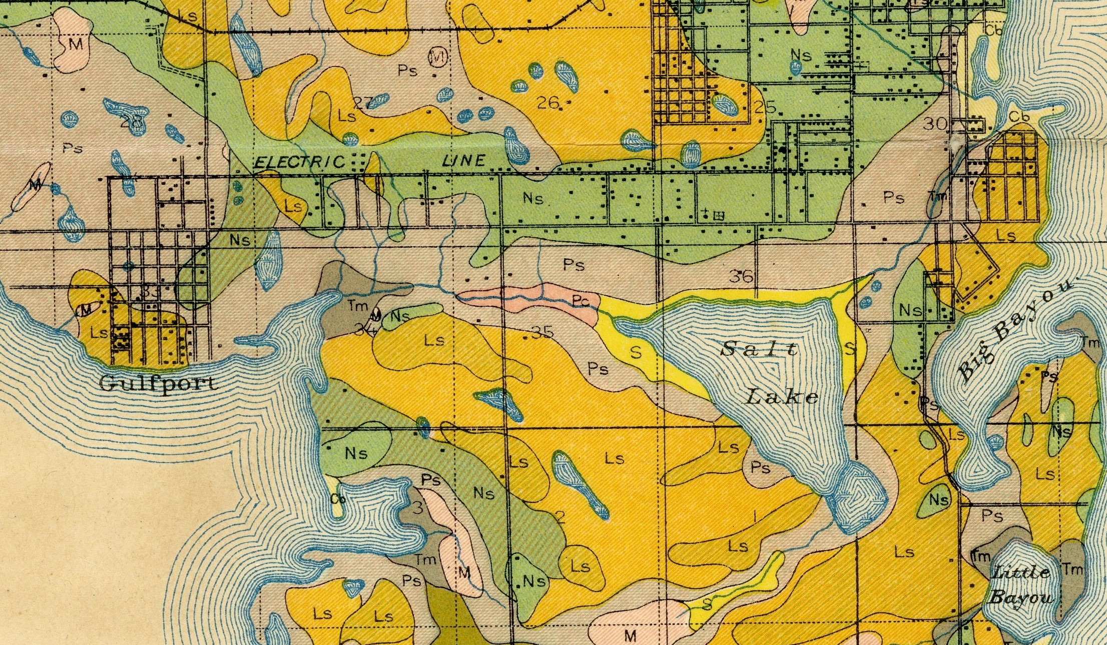
Soil map (1914), showing Salt Creek, Lake Maggiore, and Clam Bayou as one channel or swale, courtesy Pinellas County Heritage Village.
While artificial boundaries of “human” and “nature” fragment the streamshed, branches of Salt Creek reach past Lake Maggiore. This urbanized stream begs the question: how do we negotiate our relationship between the natural and built environment? Although no longer carrying a name, a small branch trickles past the nature center at Boyd Hill, under the chain-link fence outside the preserve, past Country Club Way, and into the water hazards on the St. Petersburg Country Club golf course.
When the celebrated planner John Nolen offered a plan for the city, “St. Petersburg Today, St Petersburg Tomorrow,” he envisioned a greenbelt along the low-lying swale that is the Salt Creek watershed. A chain of parks would trace the creek, link to Lake Maggiore and cross the Pinellas Peninsula’s low-lying ridge (now Interstate-275 and 34th Street South), run past Clam Bayou and connect to Gulf beaches. This plan, while environmentally progressive, did not cater to hardening racial boundaries in the United States. Racial zoning was considered requisite in the 1920s (see Richard Rothstein, The Color of Law: A Forgotten History of How Our Government Segregated America, chapter 3); Nolen advised, it was “not possible legally to set aside such districts and restrict them to any one race or color.” His prophetically-entitled plan fell casualty to Jim Crow. In 1974 the city developed a Conceptual Plan, all but replicating Nolen’s ideas, though voters struck down that progressive initiative with a voter referendum.
Today, the Salt Creek system remains largely forgotten, fragmented by development. Rosalie Peck and Jon Wilson cite a crisis of community “connectivity” in their short history, St. Petersburg’s African American Neighborhoods (2008); where the city’s Black neighborhoods previously thrived as coherent communities, this “connectivity disappeared during the second half of the twentieth century.”
The same could be said of the creek. Stripped of its names and natural course past Lake Maggiore, Salt Creek staggers through a now-uncharted chain of culverts, connectors, and smaller lakes. Along the lake’s north banks, past water view properties in the Maggiore Shores neighborhood, the city sets the low-lying land to varied uses. Dell Holmes park and a golf driving range adjoins areas purchased through the Kirby Tract, which supports a much and waste disposal property, fire-police training grounds, and the outer reaches of Boyd Hill Nature Preserve. A kayak ramp at 22nd St., the southern terminus of the celebrated “Deuces” in south St. Pete, directs paddlers into the lake–although Salt Creek continues by channel into a seldom-visited pond known “Little Lake Maggiore” or “Lake Eli.” A channel continues to run along the northern edge of the nature preserve, finally exhausting itself behind McCabe United Methodist and St. Augustine’s Episcopal Churches– congregations relocated around the time when the city’s traditionally Black Gas Plant and Campbell Park neighborhoods were razed for Interstate 275 and Tropicana Field.
A shopping plaza on 34th Street calls itself Twin Brooks Plaza, near the municipal golf course of the same name, where Salt Creek seasonally mixed with the headwaters of Clam Bayou. Maps from the early twentieth century often depict Salt Creek-Clam Bayou within a single system; wise planning in the twenty-first probably should take these earlier maps into consideration. With sea levels predicted to rise 3-6 feet in the fifty years, St. Petersburg will resemble more of an archipelago than a peninsula, with the first glimpse of that coming landscape to come from the rising, brackish waters of Salt Creek. However much we try to bend Salt Creek to our purposes, shaping the stream to economic and social uses, the water will find its course.
Note on Sources: This brief history was assembled by Thomas Hallock, working with students at the St. Petersburg campus of the University of South Florida, from searchable records of the Tampa Bay/St. Petersburg Times. Further contextualization is provided by Raymond Arsenault, St. Petersburg and the Florida Dream, 1888-1950 (1996); John A. Bethell, Pinellas: A Brief History of the Lower Point (1914); Rosalie Peck and Jon Wilson, St. Petersburg’s African American Neighborhoods (2008); Ruthmae Sears et al., Examination of Historical and Modern-Day Impact of Structural Racism on the Lives of Black People in the City of St. Petersburg, Florida (2021).